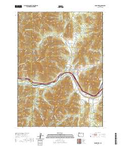
2020 Map of Rogue River
USGS Topo · Published 2020About this map
Rogue River flows through the center of this Southern Oregon landscape, where the Josephine and Jackson county lines meet amidst a complex network of gulches and ridges. The topography is defined by significant elevations such as Old Baldy, Starvation Heights, and Fielder Mtn, while the valley floor supports the community of Rogue River and the settlement at Foots Creek. Water management is a primary theme of the area's development, evidenced by the Gold Hill Irrigation District Canal and several elevated catchments like Smith Reservoir and Cold Springs Reservoir. For genealogists and local historians, the presence of the Woodville Cem and Foots Cem provides specific points for family research. The map also delineates public lands and conservation efforts at Valley of the Rogue State Pk, showing how the riverfront has been preserved even as infrastructure like the Evans Cr Lateral and various forest roads expanded into the surrounding timberlands.
Find a feature on this map
99 named features on this map. Tap any name to fly to it.
Don’t see what you’re looking for? This feature index may not catch every label — zoom into the map to look around manually.
Map Details
Editions of this 2020 Rogue River Map
This is the sole edition of this map. No revisions or reprints were ever made.
Other maps of this area

1904 · Riddle
USGS Topo · 1:125,000

1908 · Grants Pass
USGS Topo · 1:125,000

1954 · Glendale
USGS Topo · 1:62,500

1954 · Gold Hill
USGS Topo · 1:62,500

1954 · Wimer
USGS Topo · 1:62,500

1954 · Grants Pass
USGS Topo · 1:62,500

1955 · Medford
USGS Topo · 1:250,000

1957 · Medford
USGS Topo · 1:250,000

1958 · Medford
USGS Topo · 1:250,000
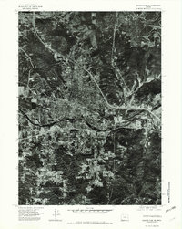
1974 · Grants Pass NE
USGS Topo · 1:24,000