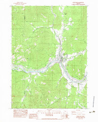
1983 Map of Rogue River
USGS Topo · Published 1983About this map
Rogue River sits at the confluence of the river that shares its name and Evans Creek, serving as a central hub for this portion of Southern Oregon in the early 1980s. The landscape is a complex network of water management and resource extraction, evidenced by the presence of the Main Canal, South Highline Canal, and a Lateral Flume designed to direct water across the varied terrain. On the southern banks of the river, Fort Birdseye marks a site of historical significance near the Rogue Valley of the Rogue State Park. The surrounding hills, including Fielder Mountain and Starvation Heights, are punctuated by mining operations such as the Shasta Mine and Owl Hollow Mine, indicating a history of mineral exploration. The boundary between Josephine and Jackson counties cuts through these timbered uplands and steep drainages like Sugar Pine Gulch.
Find a feature on this map
37 named features on this map. Tap any name to fly to it.
Don’t see what you’re looking for? This feature index may not catch every label — zoom into the map to look around manually.
Map Details
Editions of this 1983 Rogue River Map
This is the sole edition of this map. No revisions or reprints were ever made.
Other maps of this area

1904 · Riddle
USGS Topo · 1:125,000

1908 · Grants Pass
USGS Topo · 1:125,000

1954 · Glendale
USGS Topo · 1:62,500

1954 · Gold Hill
USGS Topo · 1:62,500

1954 · Wimer
USGS Topo · 1:62,500

1954 · Grants Pass
USGS Topo · 1:62,500

1955 · Medford
USGS Topo · 1:250,000

1957 · Medford
USGS Topo · 1:250,000

1958 · Medford
USGS Topo · 1:250,000
1974 · Grants Pass NE
USGS Topo · 1:24,000