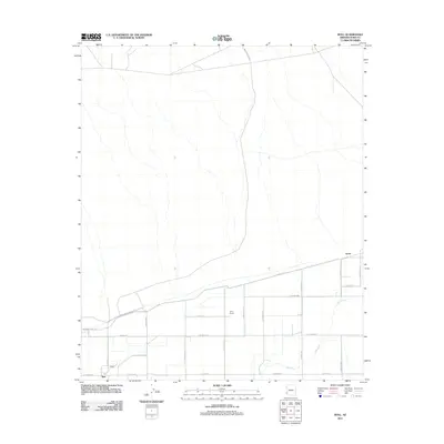
2011 Map of Roll
USGS Topo · Published 2011About this map
The agricultural landscape around Roll in Yuma County is defined by a rigid grid of roads and irrigation infrastructure south of the Gila River. This 2011 survey illustrates the high-desert farming patterns of the region, where large landholdings like Terry Ranch are integrated into a system of named avenues and streets. To the northeast, the settlement of Tyson sits at a junction of regional transit, while the Mohawk Canal Rd follows the contours of the local water management system. North of the river, the terrain shifts into more open space, intersected primarily by Wellton Kofa Rd, reflecting the transition between the managed alluvial plains and the arid desert beyond.
Find a feature on this map
24 named features on this map. Tap any name to fly to it.
Don’t see what you’re looking for? This feature index may not catch every label — zoom into the map to look around manually.
Map Details
Editions of this 2011 Roll Map
This is the sole edition of this map. No revisions or reprints were ever made.
Other maps of this area
1926 · Wellton
USGS Topo · 1:62,500
1926 · Mohawk
USGS Topo · 1:62,500
1928 · Mohawk
USGS Topo · 1:62,500
1928 · Norton
USGS Topo · 1:62,500
1929 · Wellton
USGS Topo · 1:62,500
1929 · Norton
USGS Topo · 1:62,500
1942 · Yuma
USGS Topo · 1:250,000
1953 · Ajo
USGS Topo · 1:250,000
1954 · El Centro
USGS Topo · 1:250,000
1955 · El Centro
USGS Topo · 1:250,000