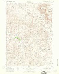
1953 Map of Rolling Pin Ranch
USGS Topo · Published 1970About this map
Pumpkin Buttes dominate the northeastern landscape of this Campbell County region, serving as prominent landmarks for the scattered ranching operations of the early 1950s. The United States Atomic Energy Commission's interest in this territory is noted in the margins, reflecting the era's focus on mineral exploration in the Powder River Basin. Settled life centers on the Rolling Pin Ranch and Pumpkin Butte Ranch, which are connected by a network of unimproved roads and trails that follow the natural drainage patterns of the high plains. Water management in this arid environment is evidenced by numerous windmills and a Water Tank strategically placed across the terrain. Seasonal watercourses like Dry Willow Creek, Cottonwood Creek, and Collins Draw carve through the landscape, defining the boundaries of grazing lands and the locations of early 20th-century homesteads.
Find a feature on this map
14 named features on this map. Tap any name to fly to it.
Don’t see what you’re looking for? This feature index may not catch every label — zoom into the map to look around manually.
Map Details
Editions of this 1953 Rolling Pin Ranch Map
3 editions found
Other maps of this area

1953 · Dry Fork Ranch
USGS Topo · 1:24,000

1953 · Fort Reno SE
USGS Topo · 1:24,000

1953 · Savageton
USGS Topo · 1:24,000

1953 · South Butte
USGS Topo · 1:24,000

1953 · Rolling Pin Ranch
USGS Topo · 1:24,000

1953 · North Butte
USGS Topo · 1:24,000

1954 · Artesian Draw
USGS Topo · 1:24,000

1954 · Pine Tree
USGS Topo · 1:24,000

1954 · Taylor Ranch
USGS Topo · 1:24,000

1955 · Newcastle
USGS Topo · 1:250,000