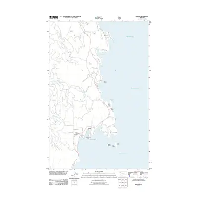
2011 Map of Rollins
USGS Topo · Published 2011About this map
The community of Rollins serves as a primary anchor on the western shores of Flathead Lake, characterized by a mix of recreational infrastructure and local civic landmarks. Along the shoreline, the map identifies significant public spaces including West Shore Campground and Glacier Campground, alongside the Big Sky RV Resort and Marina at Crescent Bay. These developments highlight the area's transition into a prominent regional destination for lakefront activity. Inland, the terrain rises toward Mount Johns, while the coast is punctuated by numerous named points and bays such as Hughes Bay, Goose Bay, and Bennetts Bay. Local history and community life are grounded in the presence of the Rollins Post Office, the Rollins Vol Fire Dept, and the United Methodist Camp, reflecting a settled landscape where residential lanes like Mabbutt Ranch Rd and Demmersville Rd meet the expansive waters of the lake.
Find a feature on this map
61 named features on this map. Tap any name to fly to it.
Don’t see what you’re looking for? This feature index may not catch every label — zoom into the map to look around manually.
Map Details
Editions of this 2011 Rollins Map
This is the sole edition of this map. No revisions or reprints were ever made.
Other maps of this area

1920 · Flathead Lake
USGS Topo · 1:125,000

1943 · Kalispell
USGS Topo · 1:125,000

1956 · Wallace
USGS Topo · 1:250,000

1957 · Kalispell
USGS Topo · 1:250,000

1960 · Kalispell
USGS Topo · 1:250,000

1960 · Wallace
USGS Topo · 1:250,000

1961 · Kalispell
USGS Topo · 1:250,000

1962 · Lion Mountain
USGS Topo · 1:24,000

1962 · Somers
USGS Topo · 1:24,000
1962 · Bigfork
USGS Topo · 1:24,000