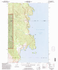
1994 Map of Rollins
USGS Topo · Published 1996About this map
Rollins sits at the heart of this coastal survey, clustered around its Post Office and Community Center where the shoreline breaks into a series of sheltered inlets. The landscape is defined by the sharp contrast between the dense heights of the Salish Mountains within the Flathead National Forest and the intricate eastern waterfront. This shoreline is a complex network of points and coves, from Angel Point in the north down to Sessions Point and the jagged Painted Rocks.
Find a feature on this map
37 named features on this map. Tap any name to fly to it.
Don’t see what you’re looking for? This feature index may not catch every label — zoom into the map to look around manually.
Map Details
Editions of this 1994 Rollins Map
This is the sole edition of this map. No revisions or reprints were ever made.
Other maps of this area

1920 · Flathead Lake
USGS Topo · 1:125,000

1943 · Kalispell
USGS Topo · 1:125,000

1956 · Wallace
USGS Topo · 1:250,000

1957 · Kalispell
USGS Topo · 1:250,000

1960 · Kalispell
USGS Topo · 1:250,000

1960 · Wallace
USGS Topo · 1:250,000

1961 · Kalispell
USGS Topo · 1:250,000

1962 · Lion Mountain
USGS Topo · 1:24,000

1962 · Somers
USGS Topo · 1:24,000
1962 · Bigfork
USGS Topo · 1:24,000