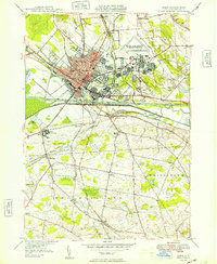
1949 Map of Rome
USGS Topo · Published 1949About this map
The industrial and military character of Oneida County is captured here in the years following World War II. The massive Rome Air Depot dominates the eastern landscape, contrasting with the dense grid of the city of Rome and its outlying neighborhoods like the Lynch Tract. This area serves as a critical transportation corridor, where the historic Barge Canal and the Mohawk River run parallel to the heavy rail lines of the New York Central.
Find a feature on this map
47 named features on this map. Tap any name to fly to it.
Don’t see what you’re looking for? This feature index may not catch every label — zoom into the map to look around manually.
Map Details
Editions of this 1949 Rome Map
This is the sole edition of this map. No revisions or reprints were ever made.
Other maps of this area

1895 · Oriskany
USGS Topo · 1:62,500

1895 · Oneida
USGS Topo · 1:62,500

1898 · Oneida
USGS Topo · 1:62,500

1898 · Oriskany
USGS Topo · 1:62,500

1902 · Oneida
USGS Topo · 1:62,500

1904 · Boonville
USGS Topo · 1:62,500

1905 · Taberg
USGS Topo · 1:62,500

1939 · Oneida
USGS Topo · 1:62,500

1943 · Lee Center
USGS Topo · 1:31,680
1946 · Oneida
USGS Topo · 1:62,500