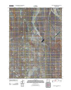
2011 Map of Rome State Airport
USGS Topo · Published 2011About this map
The high desert terrain of Malheur County dominates this 2011 survey, where the vast, unpopulated landscape is defined by its subtle topographical shifts and drainage patterns. The most prominent human-made landmark in this corner of the state is the Rome State Airport, which serves as a vital transit point in a region otherwise characterized by extreme isolation. A single north-south road corridor skirts the eastern edge of the quadrangle, representing the primary terrestrial link through this part of the Oregon desert. The map captures the area as it was recorded at the start of the second decade of the 21st century, showing a environment where natural features far outweigh human infrastructure.
Find a feature on this map
1 named feature on this map. Tap any name to fly to it.
Don’t see what you’re looking for? This feature index may not catch every label — zoom into the map to look around manually.
Map Details
Editions of this 2011 Rome State Airport Map
This is the sole edition of this map. No revisions or reprints were ever made.
Other maps of this area

1955 · Jordan Valley
USGS Topo · 1:250,000

1955 · Adel
USGS Topo · 1:250,000

1957 · Adel
USGS Topo · 1:250,000

1957 · Jordan Valley
USGS Topo · 1:250,000

1958 · Adel
USGS Topo · 1:250,000

1958 · Jordan Valley
USGS Topo · 1:250,000

1962 · Adel
USGS Topo · 1:250,000

1979 · Anderson Reservoir
USGS Topo · 1:24,000

1979 · Flat Top Mtn SE
USGS Topo · 1:24,000
1980 · Flat Top Mtn
USGS Topo · 1:24,000