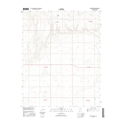
2017 Map of Romero Spring
USGS Topo · Published 2017About this map
Don Carlos Hills dominate the northern terrain of this Union County landscape, where the elevation drops away toward the south and east. A focal point of this arid region is Romero Spring, a vital water source tucked into the western slopes of the hills. The map illustrates a remote grazing or ranching environment, structured by the Public Land Survey System through several townships, including t25n r29e and t24n r30e. Low-impact infrastructure such as Gard Rd and Pasamonte Rd provide the primary access through these high plains. This contemporary survey captures the persistent rural character of northeastern New Mexico, showing how geography and water continue to dictate the placement of roads and landmarks in a largely undeveloped territory.
Find a feature on this map
10 named features on this map. Tap any name to fly to it.
Don’t see what you’re looking for? This feature index may not catch every label — zoom into the map to look around manually.
Map Details
Editions of this 2017 Romero Spring Map
This is the sole edition of this map. No revisions or reprints were ever made.
Other maps of this area

1954 · Dalhart
USGS Topo · 1:250,000

1958 · Dalhart
USGS Topo · 1:250,000

1962 · Dalhart
USGS Topo · 1:250,000

1973 · Gladstone NW
USGS Topo · 1:24,000

1973 · Tripod Mountain
USGS Topo · 1:24,000

1973 · Beenham
USGS Topo · 1:24,000

1973 · Sofia
USGS Topo · 1:24,000

1973 · Romero Spring
USGS Topo · 1:24,000
1973 · Pennington
USGS Topo · 1:24,000
1977 · Aragon Hill
USGS Topo · 1:24,000