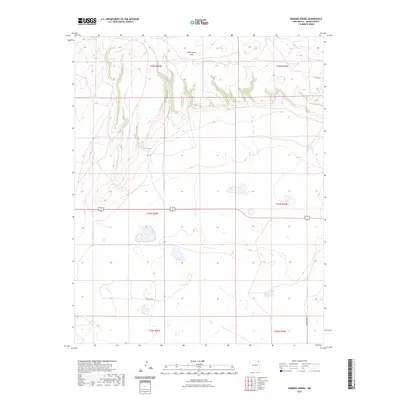
2023 Map of Romero Spring
USGS Topo · Published 2023About this map
Romero Spring provides a vital point of interest in this high plains landscape of Union County, situated along the drainage systems that carve through the northern terrain. The northern portion of the quadrangle is defined by the elevation of the Don Carlos Hills, where topographic contours reveal a complex series of ridges and draws. This modern survey reflects the enduring cattle-country layout of the region, where legacy land divisions of the Public Land Survey System define the movement of modern infrastructure. Local travel is facilitated by corridors like Gard Rd and Passamonte Rd, which intersect the expansive township and range grid. The presence of numerous seasonal wetlands and small basins across the southern sections suggests a landscape shaped by intermittent water and grazing use, typical of the high desert environment of northeastern New Mexico.
Find a feature on this map
11 named features on this map. Tap any name to fly to it.
Don’t see what you’re looking for? This feature index may not catch every label — zoom into the map to look around manually.
Map Details
Editions of this 2023 Romero Spring Map
This is the sole edition of this map. No revisions or reprints were ever made.
Other maps of this area

1954 · Dalhart
USGS Topo · 1:250,000

1958 · Dalhart
USGS Topo · 1:250,000

1962 · Dalhart
USGS Topo · 1:250,000

1973 · Gladstone NW
USGS Topo · 1:24,000

1973 · Tripod Mountain
USGS Topo · 1:24,000

1973 · Beenham
USGS Topo · 1:24,000

1973 · Sofia
USGS Topo · 1:24,000

1973 · Romero Spring
USGS Topo · 1:24,000
1973 · Pennington
USGS Topo · 1:24,000
1977 · Aragon Hill
USGS Topo · 1:24,000