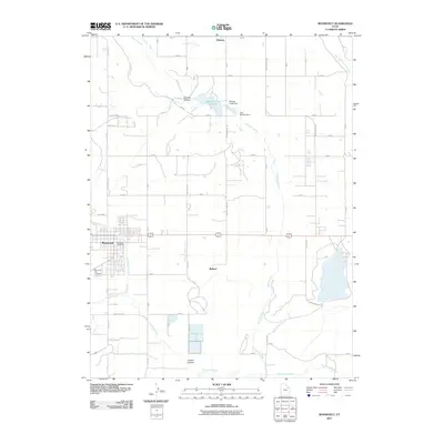
2011 Map of Roosevelt
USGS Topo · Published 2011About this map
Roosevelt and Ballard anchor this 2011 survey, showing a landscape defined by an intricate network of irrigation and water management essential to the high desert of eastern Utah. The presence of the Blackhawk Canal, State Road Lateral, and the North Lateral Canal underscores the historical reliance on diverted water to support the region's agricultural footprint. In the north, Montes Creek Reservoir is secured by both the Montes Creek Dam and Lynn Haslem Dam, while the terrain drops into significant depressions such as Montes Hollow and Cobble Hollow. For genealogists, the map identifies the Roosevelt City Cemetery and the Roosevelt Post Office, providing specific location data for town-center research. The periphery remains largely rural, featuring scattered settlements like Bennett and the winding course of Dry Gulch Creek, reflecting the area's transition from the West Channel Uinta River towards the interior plateaus.
Find a feature on this map
37 named features on this map. Tap any name to fly to it.
Don’t see what you’re looking for? This feature index may not catch every label — zoom into the map to look around manually.
Map Details
Editions of this 2011 Roosevelt Map
This is the sole edition of this map. No revisions or reprints were ever made.
Other maps of this area

1885 · Ashley
USGS Topo · 1:250,000

1885 · Uinta
USGS Topo · 1:250,000

1917 · Vernal
USGS Topo · 1:125,000

1939 · Duchesne
USGS Topo · 1:125,000

1954 · Salt Lake City
USGS Topo · 1:250,000

1954 · Vernal
USGS Topo · 1:250,000

1958 · Vernal
USGS Topo · 1:250,000

1958 · Salt Lake City
USGS Topo · 1:250,000

1960 · Salt Lake City
USGS Topo · 1:250,000

1960 · Vernal
USGS Topo · 1:250,000