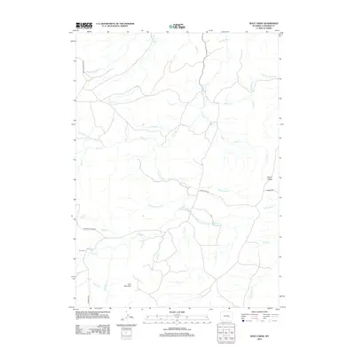
2012 Map of Root Creek
USGS Topo · Published 2012About this map
Lacy Mountain and Howard Hill define the terrain of this Wyoming landscape, where a complex network of seasonal and perennial streams creates a deeply etched drainage system. The map reveals a land structured by water, with Box Elder Creek serving as a primary artery for numerous tributaries including School Creek, Virden Creek, and Camp Creek. This ranching and grazing country is accessed by several significant routes such as Mormon Canyon Road and Windy Ridge Road, which navigate the high points between drainages.
Find a feature on this map
33 named features on this map. Tap any name to fly to it.
Don’t see what you’re looking for? This feature index may not catch every label — zoom into the map to look around manually.
Map Details
Editions of this 2012 Root Creek Map
This is the sole edition of this map. No revisions or reprints were ever made.
Other maps of this area

1949 · Careyhurst
USGS Topo · 1:24,000

1949 · Parkerton
USGS Topo · 1:24,000

1949 · Glenrock
USGS Topo · 1:24,000

1950 · Careyhurst
USGS Topo · 1:24,000

1950 · Parkerton
USGS Topo · 1:24,000

1950 · Glenrock
USGS Topo · 1:24,000

1954 · Torrington
USGS Topo · 1:250,000

1958 · Torrington
USGS Topo · 1:250,000

1964 · Buck Peak
USGS Topo · 1:24,000
1964 · Hermit Rock
USGS Topo · 1:24,000