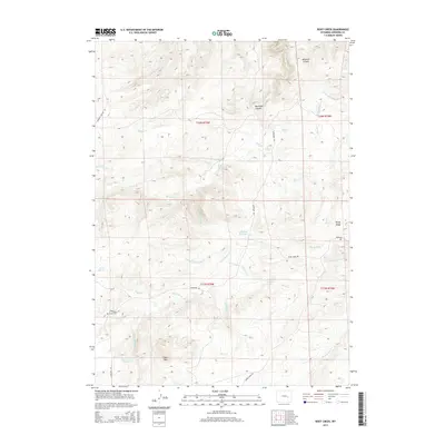
2015 Map of Root Creek
USGS Topo · Published 2015About this map
Lacy Mtn and the prominent elevations of Windy Ridge anchor this portion of Converse County, where the high plains transition into a complex network of drainages. The landscape is defined by the convergence of several major creek systems, most notably the winding course of Box Elder Cr, which carves through Box Elder Canyon in the northern reaches. For local historians and genealogists, the map preserves the location of the Grant Cem and nearby Grant Springs, providing a record of 19th-century settlement patterns in this ranching territory. Water management is evident through features like the Chas Smyth Reservoir, while the presence of School Cr and historic routes such as Mormon Canyon Rd reflect the established rural infrastructure of the region. Distinctive landmarks like Hermit Rock and Howard Hill serve as navigational waypoints amidst the intricate topography of Brighton Canyon.
Find a feature on this map
42 named features on this map. Tap any name to fly to it.
Don’t see what you’re looking for? This feature index may not catch every label — zoom into the map to look around manually.
Map Details
Editions of this 2015 Root Creek Map
This is the sole edition of this map. No revisions or reprints were ever made.
Other maps of this area

1949 · Careyhurst
USGS Topo · 1:24,000

1949 · Parkerton
USGS Topo · 1:24,000

1949 · Glenrock
USGS Topo · 1:24,000

1950 · Careyhurst
USGS Topo · 1:24,000

1950 · Parkerton
USGS Topo · 1:24,000

1950 · Glenrock
USGS Topo · 1:24,000

1954 · Torrington
USGS Topo · 1:250,000

1958 · Torrington
USGS Topo · 1:250,000

1964 · Buck Peak
USGS Topo · 1:24,000
1964 · Hermit Rock
USGS Topo · 1:24,000