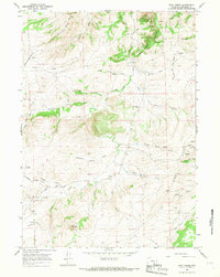
1964 Map of Root Creek
USGS Topo · Published 1968About this map
Lacy Mountain and the high ridges of Converse County define this landscape, where early ranching and rural education shaped the local geography. The map documents a sparsely settled interior during the mid-1960s, punctuated by small community anchors like Willow Dell Sch and Grant Sch. A network of unpaved tracks, including Mormon Canyon Road and Wood Road, connects isolated outposts such as Virden Camp and the small settlement of Dewey. This terrain is deeply etched by a complex drainage system featuring Box Elder Creek winding through Box Elder Canyon and the seasonal flows of White Creek and Root Creek. For genealogists and local historians, the inclusion of specific sites like Grant Cem and a lonely Grave marker near Red Canyon provides precise evidence of early inhabitants and the harsh realities of life on the Wyoming range.
Find a feature on this map
38 named features on this map. Tap any name to fly to it.
Don’t see what you’re looking for? This feature index may not catch every label — zoom into the map to look around manually.
Map Details
Editions of this 1964 Root Creek Map
This is the sole edition of this map. No revisions or reprints were ever made.
Other maps of this area

1949 · Careyhurst
USGS Topo · 1:24,000

1949 · Parkerton
USGS Topo · 1:24,000

1949 · Glenrock
USGS Topo · 1:24,000

1950 · Careyhurst
USGS Topo · 1:24,000

1950 · Parkerton
USGS Topo · 1:24,000

1950 · Glenrock
USGS Topo · 1:24,000

1954 · Torrington
USGS Topo · 1:250,000

1958 · Torrington
USGS Topo · 1:250,000

1964 · Buck Peak
USGS Topo · 1:24,000
1964 · Hermit Rock
USGS Topo · 1:24,000