
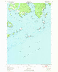
1948 Map of Roque Bluffs
USGS Topo · Published 1969About this map
Roque Bluffs occupies a dramatic position on the Maine coast, where the Englishman River meets the sea. This mid-century survey reveals a landscape defined by its intricate shoreline and maritime dependencies, featuring numerous coastal landmarks like Shoppee Pt and Black Head. The map detail includes soundings across the Gulf of Maine and Englishman Bay, charting the deep waters surrounding the Roque Island archipelago.
Find a feature on this map
63 named features on this map. Tap any name to fly to it.
Don’t see what you’re looking for? This feature index may not catch every label — zoom into the map to look around manually.
Map Details
Editions of this 1948 Roque Bluffs Map
2 editions found
Other maps of this area

1918 · Machias
USGS Topo · 1:62,500

1921 · Great Wass Island
USGS Topo · 1:62,500

1921 · Columbia Falls
USGS Topo · 1:62,500

1941 · Columbia Falls
USGS Topo · 1:62,500

1941 · Machias
USGS Topo · 1:62,500

1942 · Columbia Falls
USGS Topo · 1:62,500

1948 · Jonesport
USGS Topo · 1:24,000
1948 · Whitneyville
USGS Topo · 1:24,000
1949 · Machias
USGS Topo · 1:24,000
1949 · Cross Island
USGS Topo · 1:24,000