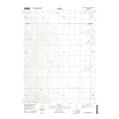
2014 Map of Rose Creek Mountain
USGS Topo · Published 2014About this map
Auld Lang Syne Peak and the surrounding East Range dominate the southern landscape of this 2014 survey. This portion of the Great Basin is defined by sharp topographic contrasts, where the high elevations of Rose Creek Mtn and the steep drainage of Badger Canyon descend into the broad expanse of Grass Valley. The map documents the boundary between Humboldt and Pershing Counties, showing how modern residential roads like Cormier Blvd and Beechcraft Blvd have begun to partition the desert floor. Water sources remain critical to the character of the region, marked by the presence of Rose Spring and the seasonal paths of Clear Cr and Sonoma Cr. The transition from the high ridges of Auld Lang Syne Gulch to the valley floor illustrates the typical basin-and-range land use patterns of northern Nevada.
Find a feature on this map
62 named features on this map. Tap any name to fly to it.
Don’t see what you’re looking for? This feature index may not catch every label — zoom into the map to look around manually.
Map Details
Editions of this 2014 Rose Creek Mountain Map
This is the sole edition of this map. No revisions or reprints were ever made.
Other maps of this area

1932 · Sonoma Range
USGS Topo · 1:250,000

1939 · Sonoma Range
USGS Topo · 1:250,000

1955 · Winnemucca
USGS Topo · 1:250,000

1958 · Winnemucca
USGS Topo · 1:250,000

1958 · Winnemucca
USGS Topo · 1:62,500

1958 · Rose Creek
USGS Topo · 1:62,500

1961 · Leach Hot Springs
USGS Topo · 1:62,500

1961 · Dun Glen
USGS Topo · 1:62,500

1962 · Winnemucca
USGS Topo · 1:250,000
1975 · Winnemucca NW
USGS Topo · 1:24,000