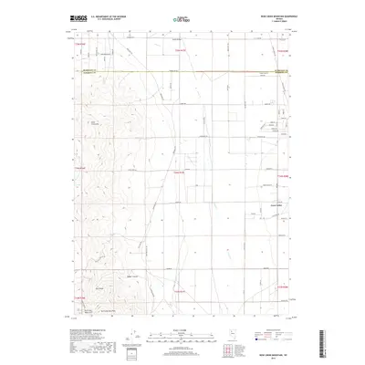
2018 Map of Rose Creek Mountain
USGS Topo · Published 2018About this map
Rose Creek Mtn and the northern reaches of the East Range dominate the western half of this Nevada landscape, transitioning into the broad basin of Grass Valley to the east. This 2018 survey captures the rugged mining and ranching geography of the Humboldt and Pershing county line. In the southern canyons, the Auld Lang Syne Mine sits near the head of Auld Lang Syne Gulch, tucked beneath the shadow of Auld Lang Syne Peak. The drainage patterns are clearly defined by seasonal watercourses like Clear Creek and Sonoma Cr which flow toward the valley floor. The map documents a sparse but intricate network of local transit including Muddy Rd and Mason Rd, alongside landmarks like Rose Spring and Badger Canyon, providing an essential reference for those studying the enduring mineral and pastoral character of this high desert region.
Find a feature on this map
72 named features on this map. Tap any name to fly to it.
Don’t see what you’re looking for? This feature index may not catch every label — zoom into the map to look around manually.
Map Details
Editions of this 2018 Rose Creek Mountain Map
This is the sole edition of this map. No revisions or reprints were ever made.
Other maps of this area

1932 · Sonoma Range
USGS Topo · 1:250,000

1939 · Sonoma Range
USGS Topo · 1:250,000

1955 · Winnemucca
USGS Topo · 1:250,000

1958 · Winnemucca
USGS Topo · 1:250,000

1958 · Winnemucca
USGS Topo · 1:62,500

1958 · Rose Creek
USGS Topo · 1:62,500

1961 · Leach Hot Springs
USGS Topo · 1:62,500

1961 · Dun Glen
USGS Topo · 1:62,500

1962 · Winnemucca
USGS Topo · 1:250,000
1975 · Winnemucca NW
USGS Topo · 1:24,000