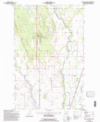
1994 Map of Rose Crossing
USGS Topo · Published 1997About this map
The Stillwater River and Whitefish River dominate this portion of the Flathead Valley, their meandering channels carving through the level floor of the basin. This landscape in the mid-1990s illustrates a transition between rural agricultural roots and modern infrastructure, anchored by the Glacier Park International Airport in the east. Local community hubs like the Birch Grove Community Center and Helena Flats Sch serve the residential clusters that have emerged along the valley floor, such as Happy Valley. Cultural markers like the Trinity Cem and Apostolic Ch provide clear reference points for genealogists tracking local families near Rose Crossing. The rail corridor of the Burlington Northern and the Somers Kalispell Branch further indicates the area's role as a transportation nexus, while numerous Gravel Pits suggest the ongoing importance of local mineral extraction to the valley's development.
Find a feature on this map
20 named features on this map. Tap any name to fly to it.
Don’t see what you’re looking for? This feature index may not catch every label — zoom into the map to look around manually.
Map Details
Editions of this 1994 Rose Crossing Map
This is the sole edition of this map. No revisions or reprints were ever made.
Other maps of this area

1943 · Kalispell
USGS Topo · 1:125,000

1957 · Kalispell
USGS Topo · 1:250,000

1960 · Kalispell
USGS Topo · 1:250,000

1961 · Kalispell
USGS Topo · 1:250,000

1962 · Columbia Falls South
USGS Topo · 1:24,000

1962 · Rose Crossing
USGS Topo · 1:24,000

1962 · Blue Grass Ridge
USGS Topo · 1:24,000

1962 · Beaver Lake
USGS Topo · 1:24,000

1962 · Creston
USGS Topo · 1:24,000

1962 · Rhodes
USGS Topo · 1:24,000