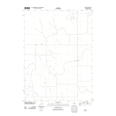
2011 Map of Rose
USGS Topo · Published 2011About this map
Rose and the nearby Duff area represent the quiet ranching and agricultural heart of Rock County in the early twenty-first century. This survey reflects a landscape defined by seasonal watercourses and local infrastructure, with Bloody Creek and Skull Creek winding through the terrain. For those researching local family roots, the Duff Cemetery stands as a primary genealogical landmark in the western portion of the quadrangle. The community's continuing role as a rural hub is anchored by the Rose Post Office, situated along the corridor of Highway 183. The map illustrates a sparse settlement pattern characteristic of the Nebraska sandhills region, where large parcels of land are punctuated by small clusters of community life and the essential transit route of the state highway.
Find a feature on this map
7 named features on this map. Tap any name to fly to it.
Don’t see what you’re looking for? This feature index may not catch every label — zoom into the map to look around manually.
Map Details
Editions of this 2011 Rose Map
This is the sole edition of this map. No revisions or reprints were ever made.
Other maps of this area

1955 · O'Neill
USGS Topo · 1:250,000

1959 · O'Neill
USGS Topo · 1:250,000

1969 · O'Neill
USGS Topo · 1:250,000

1981 · Boiling Spring
USGS Topo · 1:24,000

1981 · Stonehouse Ranch NW
USGS Topo · 1:24,000
1981 · Shovel Dot Ranch
USGS Topo · 1:24,000

1981 · Paramount Valley
USGS Topo · 1:24,000
1981 · Stonehouse Ranch SW
USGS Topo · 1:24,000

1981 · Rose
USGS Topo · 1:24,000

1982 · Stockdale Lake
USGS Topo · 1:24,000