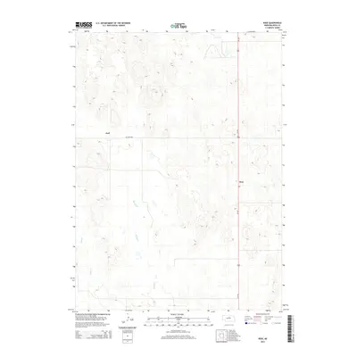
2014 Map of Rose
USGS Topo · Published 2014About this map
Rose and the surrounding rangeland of Rock County are defined by a sparse settlement pattern and the meandering drainage of the Sandhills region. This landscape features the small community of Duff near the northwestern corner, situated close to the Duff Cem which remains a significant landmark for local family history and genealogy. The terrain is marked by numerous small depressions and drainage systems, most notably Bloody Cr and Skull Cr, which provide a sense of the hydrological layout in this portion of Nebraska.
Find a feature on this map
6 named features on this map. Tap any name to fly to it.
Don’t see what you’re looking for? This feature index may not catch every label — zoom into the map to look around manually.
Map Details
Editions of this 2014 Rose Map
This is the sole edition of this map. No revisions or reprints were ever made.
Other maps of this area

1955 · O'Neill
USGS Topo · 1:250,000

1959 · O'Neill
USGS Topo · 1:250,000

1969 · O'Neill
USGS Topo · 1:250,000

1981 · Boiling Spring
USGS Topo · 1:24,000

1981 · Stonehouse Ranch NW
USGS Topo · 1:24,000
1981 · Shovel Dot Ranch
USGS Topo · 1:24,000

1981 · Paramount Valley
USGS Topo · 1:24,000
1981 · Stonehouse Ranch SW
USGS Topo · 1:24,000

1981 · Rose
USGS Topo · 1:24,000

1982 · Stockdale Lake
USGS Topo · 1:24,000