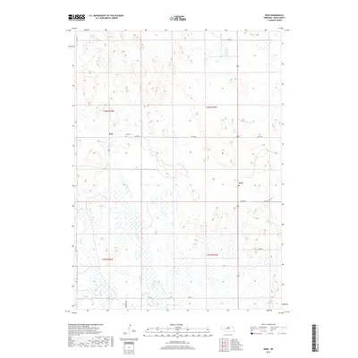
2017 Map of Rose
USGS Topo · Published 2017About this map
Rose and Duff anchor this section of Rock County, Nebraska, where the landscape is defined by the intermittent drainage patterns of the Sandhills. The topography is marked by a series of low ridges and depressions, with surface water appearing in features like Bloody Cr and Skull Cr. These watercourses flow through a region primarily organized by a rigid grid of local roads, such as Freedom Ave and 857 RD, which facilitate movement between isolated ranching properties. For local history researchers, the Duff Cem provides a tangible link to the early families of the area, situated near the namesake settlement. The layout of the section lines and township boundaries, including t26n r20w and t25n r19w, illustrates the enduring impact of the Public Land Survey System on the modern Nebraska plains.
Find a feature on this map
17 named features on this map. Tap any name to fly to it.
Don’t see what you’re looking for? This feature index may not catch every label — zoom into the map to look around manually.
Map Details
Editions of this 2017 Rose Map
This is the sole edition of this map. No revisions or reprints were ever made.
Other maps of this area

1955 · O'Neill
USGS Topo · 1:250,000

1959 · O'Neill
USGS Topo · 1:250,000

1969 · O'Neill
USGS Topo · 1:250,000

1981 · Boiling Spring
USGS Topo · 1:24,000

1981 · Stonehouse Ranch NW
USGS Topo · 1:24,000
1981 · Shovel Dot Ranch
USGS Topo · 1:24,000

1981 · Paramount Valley
USGS Topo · 1:24,000
1981 · Stonehouse Ranch SW
USGS Topo · 1:24,000

1981 · Rose
USGS Topo · 1:24,000

1982 · Stockdale Lake
USGS Topo · 1:24,000