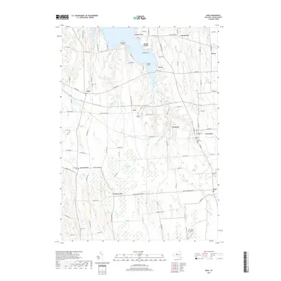
2019 Map of Rose
USGS Topo · Published 2019About this map
Sodus Bay defines the northern reaches of this Wayne County landscape, where the irregular shoreline of Sawmill Cove and Briscoe Cove meets land marked by drumlins and wetlands. The interior is characterized by agricultural stretches and small crossroads communities such as York, Glenmark, and South Sodus. The map reveals a high concentration of local burying grounds, including the York Settlement Cem and Barton Cem, which speak to the deep-rooted family history of the township. South of the bay, the extensive Huckleberry Swamp separates the northern resort-oriented settlements like Bonni Castle and Sunset View from the farming hamlets of Wayne Center and Rose. The road network, featuring named routes like Shaker Tract Rd and Pre Emption Rd, reflects centuries of movement through this drumlin-dotted terrain between the Lake Ontario shore and the Erie Canal corridor.
Find a feature on this map
101 named features on this map. Tap any name to fly to it.
Don’t see what you’re looking for? This feature index may not catch every label — zoom into the map to look around manually.
Map Details
Editions of this 2019 Rose Map
This is the sole edition of this map. No revisions or reprints were ever made.
Other maps of this area

1899 · Palmyra
USGS Topo · 1:62,500

1902 · Sodus Bay
USGS Topo · 1:62,500

1902 · Pultneyville
USGS Topo · 1:62,500

1902 · Clyde
USGS Topo · 1:62,500

1902 · Palmyra
USGS Topo · 1:62,500

1943 · Lyons
USGS Topo · 1:31,680

1943 · Sodus Point
USGS Topo · 1:31,680

1943 · Savannah
USGS Topo · 1:31,680

1943 · Sodus
USGS Topo · 1:31,680

1943 · Wolcott
USGS Topo · 1:31,680