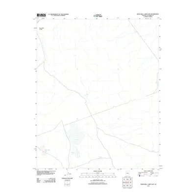
2011 Map of Rose Well Camp East
USGS Topo · Published 2011About this map
Rose Well Camp sits in the northwest corner of this Coconino County landscape, where the high desert terrain is defined by a critical network of water management features. The area is dominated by the expansive Red Lake and its smaller counterpart, Little Red Lake, which serve as focal points for the surrounding drainage. An Aqueduct enters from the northern margin, feeding into a distribution system of numerous earthen tanks that support livestock or local needs. These specific landmarks, including Furguson Tank, Rodgers Tank, and End of Line Tank, reveal how the ranching or land-management infrastructure is organized across this arid territory. The presence of both Big Sullivan Tank and Little Sullivan Tank further emphasizes the reliance on these localized water sources in a region where natural surface water is ephemeral and carefully captured.
Find a feature on this map
10 named features on this map. Tap any name to fly to it.
Don’t see what you’re looking for? This feature index may not catch every label — zoom into the map to look around manually.
Map Details
Editions of this 2011 Rose Well Camp East Map
This is the sole edition of this map. No revisions or reprints were ever made.
Other maps of this area

1886 · Chino
USGS Topo · 1:250,000

1891 · Chino
USGS Topo · 1:250,000

1948 · Williams
USGS Topo · 1:250,000

1954 · Williams
USGS Topo · 1:250,000

1956 · Williams
USGS Topo · 1:250,000

1960 · Williams
USGS Topo · 1:250,000

1961 · Williams
USGS Topo · 1:250,000
1980 · Rose Well Camp West
USGS Topo · 1:24,000

1980 · Hazen Hole Tank
USGS Topo · 1:24,000
1980 · Black Tank
USGS Topo · 1:24,000