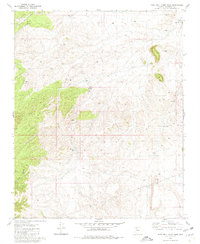
1980 Map of Rose Well Camp West
USGS Topo · Published 1980About this map
The Hualapai Indian Reservation defines the high plateau of the northwestern corner of this map, giving way to the complex drainage of Crater Canyon to the south. This arid landscape is dominated by essential water infrastructure supporting cattle ranching and remote outposts. Named watering points such as Wheat Tub, Tub No 3, and Tub No 1 are scattered across the terrain, indicating a carefully managed system of tanks and wells. The tiny settlement at Rose Well Camp in the northeast and a lone Corral near the center reflect the sparse human imprint on this territory. The presence of Owen Dam suggests efforts to capture seasonal runoff in a region where water security dictated the location of every camp and stock tank.
Find a feature on this map
15 named features on this map. Tap any name to fly to it.
Don’t see what you’re looking for? This feature index may not catch every label — zoom into the map to look around manually.
Map Details
Editions of this 1980 Rose Well Camp West Map
This is the sole edition of this map. No revisions or reprints were ever made.
Other maps of this area

1886 · Diamond Creek
USGS Topo · 1:250,000

1886 · Chino
USGS Topo · 1:250,000

1891 · Chino
USGS Topo · 1:250,000

1892 · Diamond Creek
USGS Topo · 1:250,000

1948 · Williams
USGS Topo · 1:250,000

1954 · Williams
USGS Topo · 1:250,000

1956 · Williams
USGS Topo · 1:250,000

1960 · Williams
USGS Topo · 1:250,000

1961 · Williams
USGS Topo · 1:250,000
1967 · Frazier Wells
USGS Topo · 1:24,000