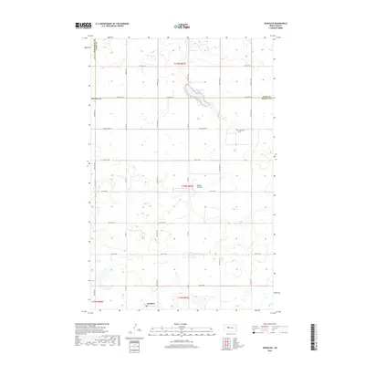
2018 Map of Roseglen
USGS Topo · Published 2018About this map
Roseglen sits at the intersection of a vast grid of county roads in North Dakota, representing a quintessential Great Plains agricultural landscape. This portion of the Missouri Plateau is defined by its glacial prairie potholes and seasonal wetlands, which scatter across the terrain between the heights of Round Top Hill. The map traces the political boundaries where McLean Co, Ward Co, and Mountrail Co meet, a detail of significance for local researchers tracing jurisdictional history. Key landmarks like Hiddenwood Lake and the nearby Hiddenwood Cem provide a focal point for the surrounding rural sections. The intricate network of section-line roads, including Co Hwy 7 and Co Rd 9, illustrates the enduring structure of the Public Land Survey System in this region.
Find a feature on this map
31 named features on this map. Tap any name to fly to it.
Don’t see what you’re looking for? This feature index may not catch every label — zoom into the map to look around manually.
Map Details
Editions of this 2018 Roseglen Map
This is the sole edition of this map. No revisions or reprints were ever made.
Other maps of this area

1954 · McClusky
USGS Topo · 1:250,000

1956 · Makoti SW
USGS Topo · 1:24,000

1956 · Blackwater Lake NW
USGS Topo · 1:24,000

1956 · Blackwater Lake
USGS Topo · 1:24,000

1956 · Blue Hill
USGS Topo · 1:24,000

1956 · Emmet
USGS Topo · 1:24,000

1956 · Roseglen
USGS Topo · 1:24,000

1958 · McClusky
USGS Topo · 1:250,000

1980 · Makoti
USGS Topo · 1:24,000
1980 · Wabek
USGS Topo · 1:24,000