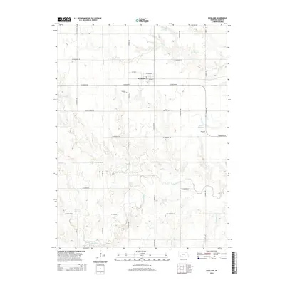
2014 Map of Roseland
USGS Topo · Published 2014About this map
The village of Roseland serves as the central hub for this corner of Adams County, where the agricultural landscape is defined by an intricate network of section-line roads and prairie drainage systems. The Little Blue River winds through the southern portion of the quadrangle, joined by numerous tributaries including Cottonwood Cr, Sand Cr, and Rabbit Run Cr. These waterways are punctuated by several small reservoirs like Trausch Reservoir and Larsen Reservoir, reflecting the region's managed water resources for Nebraska's farm economy.
Find a feature on this map
31 named features on this map. Tap any name to fly to it.
Don’t see what you’re looking for? This feature index may not catch every label — zoom into the map to look around manually.
Map Details
Editions of this 2014 Roseland Map
This is the sole edition of this map. No revisions or reprints were ever made.
Other maps of this area

1894 · Kenesaw
USGS Topo · 1:62,500

1896 · Wood River
USGS Topo · 1:125,000

1897 · Red Cloud
USGS Topo · 1:125,000

1898 · Superior
USGS Topo · 1:125,000

1898 · Grand Island
USGS Topo · 1:125,000

1955 · Grand Island
USGS Topo · 1:250,000

1957 · Grand Island
USGS Topo · 1:250,000

1958 · Grand Island
USGS Topo · 1:250,000

1969 · Blue Hill
USGS Topo · 1:24,000
1969 · Holstein
USGS Topo · 1:24,000