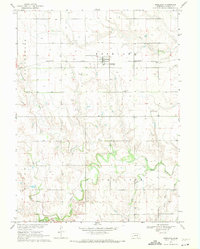
1969 Map of Roseland
USGS Topo · Published 1971About this map
Roseland stands as the primary hub of this Adams County landscape, situated along the Burlington Northern railroad corridor. The surrounding terrain is defined by the winding course of the Little Blue River and its numerous tributaries, including Cottonwood Creek and Scott Creek, which carve through the plains. This 1969 field-checked survey reveals a rural society organized around established townships like Silver Lake and Cottonwood, where the placement of the Roseland Cem, Silver Lake Cem, and Mennonite Cem suggests deep-rooted community ties. The high density of wells across the agricultural sections reflects the intensive land use of the late 1960s. These details offer a clear view of the water-dependent infrastructure and transportation networks that supported this Nebraska farming community before modern expansion.
Find a feature on this map
15 named features on this map. Tap any name to fly to it.
Don’t see what you’re looking for? This feature index may not catch every label — zoom into the map to look around manually.
Map Details
Editions of this 1969 Roseland Map
This is the sole edition of this map. No revisions or reprints were ever made.
Other maps of this area

1894 · Kenesaw
USGS Topo · 1:62,500

1896 · Wood River
USGS Topo · 1:125,000

1897 · Red Cloud
USGS Topo · 1:125,000

1898 · Superior
USGS Topo · 1:125,000

1898 · Grand Island
USGS Topo · 1:125,000

1955 · Grand Island
USGS Topo · 1:250,000

1957 · Grand Island
USGS Topo · 1:250,000

1958 · Grand Island
USGS Topo · 1:250,000

1969 · Blue Hill
USGS Topo · 1:24,000
1969 · Holstein
USGS Topo · 1:24,000