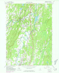
1964 Map of Rosendale
USGS Topo · Published 1980About this map
Rondout Creek and the Wallkill River converge in this mid-century portrait of Ulster County, where industrial history meets the rising peaks of the Shawangunk Mountains. The landscape is defined by its diverse water systems, from the expansive Sturgeon Pool to the secluded Binnewater Lakes. Evidence of the region's productive past is scattered throughout, including a Grist Mill near Tillson and an Old Railroad Grade that winds past Lawrenceville and Rosendale.
Find a feature on this map
65 named features on this map. Tap any name to fly to it.
Don’t see what you’re looking for? This feature index may not catch every label — zoom into the map to look around manually.
Map Details
Editions of this 1964 Rosendale Map
Other maps of this area

1893 · Poughkeepsie
USGS Topo · 1:62,500

1894 · Poughkeepsie
USGS Topo · 1:62,500

1898 · Rhinebeck
USGS Topo · 1:62,500

1901 · Rosendale
USGS Topo · 1:62,500

1903 · Poughkeepsie
USGS Topo · 1:62,500

1903 · Newburg
USGS Topo · 1:62,500

1903 · Rosendale
USGS Topo · 1:62,500

1934 · Rhinebeck
USGS Topo · 1:48,000

1936 · Poughkeepsie
USGS Topo · 1:48,000

1939 · Rhinebeck
USGS Topo · 1:62,500