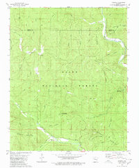
1980 Map of Rosetta
USGS Topo · Published 1980About this map
Rosetta stands as a quiet settlement within the high ridges and deep hollows of the Ozark National Forest, where the topography is defined by the winding course of Big Piney Creek and its many tributaries. This 1980 survey reveals a landscape of varied elevation, from the heights of Pilot Rock Mountain and Ozone Mountain to the secluded depths of Childers Hollow and Bowman Hollow. The distribution of small family and community sites like Rosetta Cem and Union Cem suggests a history of remote mountain living connected by a network of ridgeline routes like Parker Ridge Road.
Find a feature on this map
36 named features on this map. Tap any name to fly to it.
Don’t see what you’re looking for? This feature index may not catch every label — zoom into the map to look around manually.
Map Details
Editions of this 1980 Rosetta Map
This is the sole edition of this map. No revisions or reprints were ever made.
Other maps of this area

1889 · Treat
USGS Topo · 1:62,500

1889 · Ozone
USGS Topo · 1:62,500

1932 · Treat
USGS Topo · 1:62,500

1933 · Mt Judea
USGS Topo · 1:62,500

1934 · Treat
USGS Topo · 1:62,500

1934 · Ozone
USGS Topo · 1:62,500

1936 · Ozone
USGS Topo · 1:62,500

1940 · Mt Judea
USGS Topo · 1:62,500

1956 · Russellville
USGS Topo · 1:250,000

1964 · Russellville
USGS Topo · 1:250,000