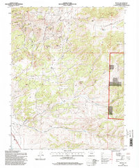
1994 Map of Rosita
USGS Topo · Published 1998About this map
Rosita and Querida sit at the center of this mountain landscape, reflecting a region defined by historical mining activity and high-altitude ranching. Evidence of the area's extraction history is visible through numerous prospects and a Perlite Quarry located near Pioneer Cem. The terrain is characterized by the prominent Rosita Hills and a series of named peaks including Pocahontas Hill, Mount Fairview, and Mount Robinson. To the east, the boundary of the San Isabel National Forest borders the high meadows of Junkins Park. The drainage network, featuring Cottonwood Gulch and Antelope Creek, illustrates the complex topography that early settlers and miners navigated. Established family operations like the Smith Ranch and Hobbs Ranch are documented alongside a remote Landing Strip, showing how this isolated Custer County terrain was accessed in the late twentieth century.
Find a feature on this map
40 named features on this map. Tap any name to fly to it.
Don’t see what you’re looking for? This feature index may not catch every label — zoom into the map to look around manually.
Map Details
Editions of this 1994 Rosita Map
This is the sole edition of this map. No revisions or reprints were ever made.
Other maps of this area

1889 · Canon City
USGS Topo · 1:125,000

1889 · Huerfano Park
USGS Topo · 1:125,000

1892 · Huerfano Park
USGS Topo · 1:125,000

1892 · Canon City
USGS Topo · 1:125,000

1954 · Mount Tyndall
USGS Topo · 1:24,000

1954 · Rosita
USGS Topo · 1:24,000

1954 · Trinidad
USGS Topo · 1:250,000

1954 · Pueblo
USGS Topo · 1:250,000

1955 · Westcliffe
USGS Topo · 1:24,000

1955 · Trinidad
USGS Topo · 1:250,000