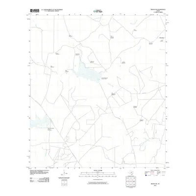
2010 Map of Rosita NE
USGS Topo · Published 2010About this map
Water infrastructure and intermittent ranching resources define this South Texas landscape, where the ephemeral flow of Chiltipin Creek and Palo Amarillo Creek is managed by features like the Soil Conservation Service 2 Dam. The area's agricultural heritage is etched into the map through a dense network of family-named landmarks, specifically windmills that served as vital survival points in the arid brush country. This includes Horcones Windmill, Palo Blanco Windmill, and Las Muchachas Windmill. Genealogists will find particular value in the presence of the Perez Cemetery and Garcia Cemetery located near Mendiates, suggesting the deep-rooted family ties that persist in this corner of Duval County. The road network, including the evocative Old Seven Sisters Rd, connects these remote outposts across a terrain of winding creeks like Gato Creek and Toro Creek.
Find a feature on this map
27 named features on this map. Tap any name to fly to it.
Don’t see what you’re looking for? This feature index may not catch every label — zoom into the map to look around manually.
Map Details
Editions of this 2010 Rosita NE Map
This is the sole edition of this map. No revisions or reprints were ever made.
Other maps of this area

1920 · Mikeska
USGS Topo · 1:125,000

1920 · San Diego
USGS Topo · 1:62,500

1953 · Crystal City
USGS Topo · 1:250,000

1955 · Crystal City
USGS Topo · 1:250,000

1956 · Rosita Ranch
USGS Topo · 1:62,500

1956 · Laredo
USGS Topo · 1:250,000

1961 · Crystal City
USGS Topo · 1:250,000
1963 · Anna Rose
USGS Topo · 1:24,000

1963 · San Diego
USGS Topo · 1:24,000
1963 · Shaeffer Ranch
USGS Topo · 1:24,000