1946 Map of Rosman
USGS Topo · Published 1947About this map
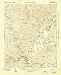
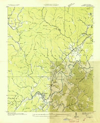
Rosman serves as the hub of this mid-century Transylvania County landscape, situated where the forks of the French Broad River converge. The Southern Railway winds through the river valleys, connecting small settlements like Balsam Grove, Powelltown, and Bovina. The area is characterized by a mix of deep-woods infrastructure and recreational development, featuring the State Prison Camp near Calvert alongside numerous summer retreats such as Camp Illahee, Keystone Camp, and Camp Cherryfield.
Find a feature on this map
151 named features on this map. Tap any name to fly to it.
Don’t see what you’re looking for? This feature index may not catch every label — zoom into the map to look around manually.
Map Details
Editions of this 1946 Rosman Map
This is the sole edition of this map. No revisions or reprints were ever made.
Other maps of this area

1905 · Pisgah
USGS Topo · 1:125,000

1906 · Pisgah
USGS Topo · 1:125,000

1935 · Brevard
USGS Topo · 1:24,000

1935 · Eastatoe Gap
USGS Topo · 1:24,000

1935 · Sam Knob
USGS Topo · 1:24,000
1935 · Rosman
USGS Topo · 1:24,000

1935 · Lake Toxaway
USGS Topo · 1:24,000

1935 · Reid
USGS Topo · 1:24,000

1935 · Table Rock
USGS Topo · 1:24,000

1935 · Shining Rock
USGS Topo · 1:24,000