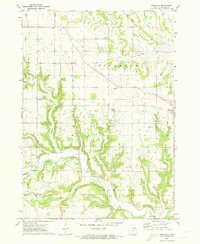
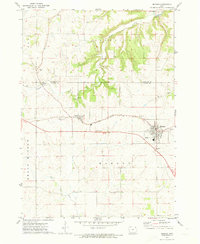
1971 Map of Rossville
USGS Topo · Published 1973About this map
The Yellow River carves a deep path through the southern half of this landscape, joined by Williams Creek and Bear Creek as it winds toward the Mississippi. This 1971 survey captures the rural character of Allamakee County, where the settlement of Rossville serves as a local hub near the Rossville Cem. The terrain is defined by the complex drainage systems of Paint Creek to the north and Norfolk Creek to the west, creating a series of high ridges and narrow valleys that dictate the placement of roads and farmsteads. Local history is anchored by several burial grounds including Evergreen Cem and Ebenezer Cem, while the Forest Mills Ch stands as a spiritual landmark near the river. Economic activity is visible in the numerous Quarries and a Quarry dotting the hillsides, illustrating the importance of local stone extraction to the region's development.
Find a feature on this map
17 named features on this map. Tap any name to fly to it.
Don’t see what you’re looking for? This feature index may not catch every label — zoom into the map to look around manually.
Map Details
Editions of this 1971 Rossville Map
This is the sole edition of this map. No revisions or reprints were ever made.
Other maps of this area

1903 · Waukon
USGS Topo · 1:125,000

1906 · Decorah
USGS Topo · 1:125,000

1958 · La Crosse
USGS Topo · 1:250,000

1961 · La Crosse
USGS Topo · 1:250,000

1965 · La Crosse
USGS Topo · 1:250,000
1968 · Church
USGS Topo · 1:24,000

1968 · Waukon
USGS Topo · 1:24,000
1971 · Postville
USGS Topo · 1:24,000
1971 · Waterville
USGS Topo · 1:24,000
1971 · Monona
USGS Topo · 1:24,000