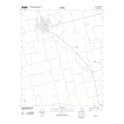
2010 Map of Rotan
USGS Topo · Published 2010About this map
The town of Rotan dominates the northern landscape of this Fisher County region, defined by its rigid grid of residential streets and thoroughfares like Jackson Ave and Van Buren Ave. This agricultural and ranching heartland of West Texas follows a pattern of widely spaced settlements and rural infrastructure. Small communities and historical points such as North Roby, Fisher, and Sardis dot the expansive terrain, connected by a network of farm roads and county routes. The drainage patterns of the Clear Fork and Alkali Creek cut across the landscape, providing essential water sources in this semi-arid environment. Local history is anchored by sites like the Rotan Cemetery and Fisher Cemetery, while the Fisher County Airport reflects the modernization of transportation in the area. The map illustrates how human settlement has adapted to the natural watercourses and the vast distances between rural centers.
Find a feature on this map
44 named features on this map. Tap any name to fly to it.
Don’t see what you’re looking for? This feature index may not catch every label — zoom into the map to look around manually.
Map Details
Editions of this 2010 Rotan Map
This is the sole edition of this map. No revisions or reprints were ever made.
Other maps of this area

1893 · Roby
USGS Topo · 1:125,000

1926 · Snyder 1-a
USGS Topo · 1:48,000

1926 · Roby 2-b
USGS Topo · 1:48,000

1931 · Rotan
USGS Topo · 1:62,500

1932 · Camp Springs
USGS Topo · 1:62,500

1954 · Big Spring
USGS Topo · 1:250,000

1958 · Big Spring
USGS Topo · 1:250,000
1969 · White Canyon
USGS Topo · 1:24,000
1969 · Poke Mountain
USGS Topo · 1:24,000

1969 · Rotan
USGS Topo · 1:24,000