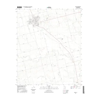
2016 Map of Rotan
USGS Topo · Published 2016About this map
The agricultural landscape of central Fisher County is anchored by Rotan and Roby, the latter appearing at the southern edge of the sheet. This 2016 survey illustrates the grid-like organization of the Texas ranching and farming country, where an extensive network of county roads, such as Co RD 324 and Co RD 310, connects isolated homesteads and town centers. The drainage of Clear Fork and Alkali Cr cuts through the terrain, providing the primary topographical relief in an otherwise systematically partitioned territory. Genealogists and local historians can pinpoint significant sites like Rotan Cem northeast of the main town and the more isolated Fisher Cem situated among the fields to the east. The presence of the Fisher County Airport emphasizes the area's continued reliance on regional transportation infrastructure in the modern era.
Find a feature on this map
80 named features on this map. Tap any name to fly to it.
Don’t see what you’re looking for? This feature index may not catch every label — zoom into the map to look around manually.
Map Details
Editions of this 2016 Rotan Map
This is the sole edition of this map. No revisions or reprints were ever made.
Other maps of this area

1893 · Roby
USGS Topo · 1:125,000

1926 · Snyder 1-a
USGS Topo · 1:48,000

1926 · Roby 2-b
USGS Topo · 1:48,000

1931 · Rotan
USGS Topo · 1:62,500

1932 · Camp Springs
USGS Topo · 1:62,500

1954 · Big Spring
USGS Topo · 1:250,000

1958 · Big Spring
USGS Topo · 1:250,000
1969 · White Canyon
USGS Topo · 1:24,000
1969 · Poke Mountain
USGS Topo · 1:24,000

1969 · Rotan
USGS Topo · 1:24,000