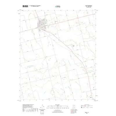
2019 Map of Rotan
USGS Topo · Published 2019About this map
Rotan serves as a primary hub of settlement in Fisher County, showing a tight grid of streets situated north of the Fisher County Airport. The landscape is defined by the winding course of the Clear Fork Brazos River, which meanders across the central and southern portions of the territory. To the south, the community of Roby sits near the junction of several county roads and the drainage of Alkali Cr. This 2019 survey documents the rural infrastructure of the region, where a dense network of Farm to Market roads like FM 611 and FM 2832 connect isolated farmsteads and historic burial sites such as Rotan Cem and Fisher Cem. The mapping reveals the transition from the structured residential blocks of the towns to the open, creek-carved plains of West Texas.
Find a feature on this map
72 named features on this map. Tap any name to fly to it.
Don’t see what you’re looking for? This feature index may not catch every label — zoom into the map to look around manually.
Map Details
Editions of this 2019 Rotan Map
This is the sole edition of this map. No revisions or reprints were ever made.
Other maps of this area

1893 · Roby
USGS Topo · 1:125,000

1926 · Snyder 1-a
USGS Topo · 1:48,000

1926 · Roby 2-b
USGS Topo · 1:48,000

1931 · Rotan
USGS Topo · 1:62,500

1932 · Camp Springs
USGS Topo · 1:62,500

1954 · Big Spring
USGS Topo · 1:250,000

1958 · Big Spring
USGS Topo · 1:250,000
1969 · White Canyon
USGS Topo · 1:24,000
1969 · Poke Mountain
USGS Topo · 1:24,000

1969 · Rotan
USGS Topo · 1:24,000