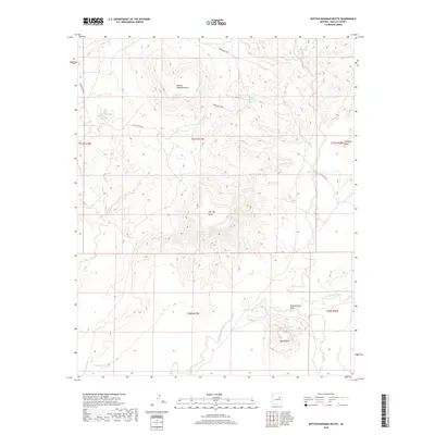
2018 Map of Rotten Bananas Butte
USGS Topo · Published 2018About this map
Rotten Bananas Butte and Flat Top Butte dominate this Navajo County landscape, where water sources are primarily ephemeral washes and scattered springs. The topography is defined by the drainages of Humpy Wash and Cottonwood Wash, which cut through the high desert terrain. Significant water points for land use and ranching are documented, including Mackelprang Spring, Black Rock Spring, and the man-made Humpy Tank.
Find a feature on this map
22 named features on this map. Tap any name to fly to it.
Don’t see what you’re looking for? This feature index may not catch every label — zoom into the map to look around manually.
Map Details
Editions of this 2018 Rotten Bananas Butte Map
This is the sole edition of this map. No revisions or reprints were ever made.
Other maps of this area

1883 · Tusayan
USGS Topo · 1:250,000

1886 · Tusayan
USGS Topo · 1:250,000

1947 · Flagstaff
USGS Topo · 1:250,000

1954 · Flagstaff
USGS Topo · 1:250,000

1955 · Mal Pais Springs 3 SW
USGS Topo · 1:24,000

1958 · Flagstaff
USGS Topo · 1:250,000

1960 · Flagstaff
USGS Topo · 1:250,000

1962 · Flagstaff
USGS Topo · 1:250,000
1967 · French Butte
USGS Topo · 1:24,000
1967 · Chimney Butte
USGS Topo · 1:24,000