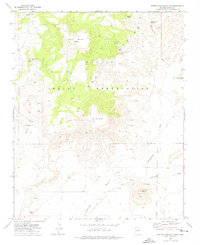
1972 Map of Rotten Bananas Butte
USGS Topo · Published 1975About this map
The high desert landscape of the Navajo Indian Reservation is defined by isolated landmarks and critical water sources in this early 1970s survey. Dominating the northern horizon, the whimsically named Rotten Bananas Butte stands near the Apollo marker, while Flat Top Butte anchors the central terrain. The distribution of life here is traced through scattered ranching infrastructure and hydrological features, including the Black Rock Ranch and named watering points such as Tsosie Well and the Wash Dug Well.
Find a feature on this map
27 named features on this map. Tap any name to fly to it.
Don’t see what you’re looking for? This feature index may not catch every label — zoom into the map to look around manually.
Map Details
Editions of this 1972 Rotten Bananas Butte Map
This is the sole edition of this map. No revisions or reprints were ever made.
Other maps of this area

1883 · Tusayan
USGS Topo · 1:250,000

1886 · Tusayan
USGS Topo · 1:250,000

1947 · Flagstaff
USGS Topo · 1:250,000

1954 · Flagstaff
USGS Topo · 1:250,000

1955 · Mal Pais Springs 3 SW
USGS Topo · 1:24,000

1958 · Flagstaff
USGS Topo · 1:250,000

1960 · Flagstaff
USGS Topo · 1:250,000

1962 · Flagstaff
USGS Topo · 1:250,000
1967 · French Butte
USGS Topo · 1:24,000
1967 · Chimney Butte
USGS Topo · 1:24,000