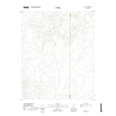
2019 Map of Rotten Hill
USGS Topo · Published 2019About this map
Rotten Hill serves as a central landmark in this portion of the Texas Panhandle, situated near the boundary between Oldham and Potter counties. The landscape is defined by an intricate network of drainage systems, including the notable Five Fingers landform and the deep carving of Hand Draw. These topographical features feed into a series of creeks that crisscross the terrain, such as Sierrita de la Cruz Cr in the north and Wildorado Cr and Goodman Cr further south. The map reflects a predominantly rural and open character, with human infrastructure represented by few corridors like Locust St. The convergence of Daniels Cr, Willow Cr, and Pedrosa Cr illustrates the complex natural hydrology that dictates the movement of water across this high plains environment.
Find a feature on this map
12 named features on this map. Tap any name to fly to it.
Don’t see what you’re looking for? This feature index may not catch every label — zoom into the map to look around manually.
Map Details
Editions of this 2019 Rotten Hill Map
This is the sole edition of this map. No revisions or reprints were ever made.
Other maps of this area

1934 · Ady
USGS Topo · 1:62,500

1936 · Ady
USGS Topo · 1:62,500

1954 · Tucumcari
USGS Topo · 1:250,000

1958 · Tucumcari
USGS Topo · 1:250,000

1962 · Wildorado
USGS Topo · 1:62,500

1965 · Everett
USGS Topo · 1:24,000
1966 · Boden
USGS Topo · 1:24,000

1966 · Jay Taylor Ranch
USGS Topo · 1:24,000

1966 · Halfway Creek
USGS Topo · 1:24,000

1966 · Ady
USGS Topo · 1:24,000