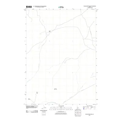
2010 Map of Rough Mountain
USGS Topo · Published 2010About this map
Rough Mountain and the high desert terrain of Owyhee County define this 2010 survey, capturing a landscape dominated by drainage systems and mountain passes. The presence of Doyle Place north of the mountain suggests a remote homestead or ranching site established within this dry interior, situated near the headwaters of Birch Creek. This watercourse, along with Lone Juniper Creek and Poison Creek, dictates the movement across the terrain, where topographical gaps like Half Moon Pass and Little Half Moon Pass provide natural corridors for transit. The human footprint is marked primarily by infrastructure like Mud Flat Rd and the Poison Creek Cutoff, tracing routes that connect these isolated water sources and elevation points. The map reflects a modern record of a sparsely populated region where traditional land use and natural geography remain closely intertwined.
Find a feature on this map
9 named features on this map. Tap any name to fly to it.
Don’t see what you’re looking for? This feature index may not catch every label — zoom into the map to look around manually.
Map Details
Editions of this 2010 Rough Mountain Map
This is the sole edition of this map. No revisions or reprints were ever made.
Other maps of this area

1947 · Grand View
USGS Topo · 1:62,500

1947 · Vinson Wash
USGS Topo · 1:24,000

1947 · Perjue Canyon
USGS Topo · 1:24,000

1948 · Perjue Canyon
USGS Topo · 1:24,000

1948 · Vinson Wash
USGS Topo · 1:24,000

1955 · Jordan Valley
USGS Topo · 1:250,000

1957 · Jordan Valley
USGS Topo · 1:250,000

1958 · Jordan Valley
USGS Topo · 1:250,000
1972 · Rough Mountain NE
USGS Topo · 1:24,000
1972 · Rough Mountain
USGS Topo · 1:24,000