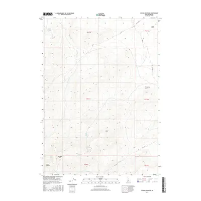
2017 Map of Rough Mountain
USGS Topo · Published 2017About this map
Rough Mountain dominates this high-desert landscape in Owyhee County, where a series of water sources and passes define the movement through the terrain. The network of seasonal hydrology is evident in the numerous named springs, such as Poison Gulch Spring, Little Half Moon Spring, and Eagle Spring, which likely served as critical landmarks for travelers and ranching operations. The presence of Half Moon Pass and Little Half Moon Pass indicates established routes through the mountainous interior, connecting the drainages of Birch Cr and Poison Cr. While roads like Mud Flat Rd and Missile Base Rd provide modern access, the distribution of names like Vinson Wash and Twentymile Gulch reflects a landscape mapped and navigated by its distinct geological and hydrological features.
Find a feature on this map
25 named features on this map. Tap any name to fly to it.
Don’t see what you’re looking for? This feature index may not catch every label — zoom into the map to look around manually.
Map Details
Editions of this 2017 Rough Mountain Map
This is the sole edition of this map. No revisions or reprints were ever made.
Other maps of this area

1947 · Grand View
USGS Topo · 1:62,500

1947 · Vinson Wash
USGS Topo · 1:24,000

1947 · Perjue Canyon
USGS Topo · 1:24,000

1948 · Perjue Canyon
USGS Topo · 1:24,000

1948 · Vinson Wash
USGS Topo · 1:24,000

1955 · Jordan Valley
USGS Topo · 1:250,000

1957 · Jordan Valley
USGS Topo · 1:250,000

1958 · Jordan Valley
USGS Topo · 1:250,000
1972 · Rough Mountain NE
USGS Topo · 1:24,000
1972 · Rough Mountain
USGS Topo · 1:24,000