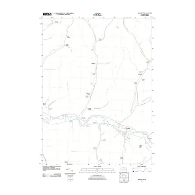
2010 Map of Roulette
USGS Topo · Published 2010About this map
The Allegheny River valley dictates the settlement pattern of this northern Pennsylvania landscape, where the communities of Roulette and Burtville are established along the river's course. Numerous named hollows, such as Hanson Hollow, Meacham Hollow, and Dexter Hollow, drain into the primary water systems of Sartwell Creek and Fishing Creek, reflecting a geography defined by narrow valleys and upland ridges like Clara Hill and Shingle Cabin Hill. The map provides significant genealogical value through the identification of local burial sites, including Card Creek Cemetery, Lyman Cemetery, and Hill Cemetery. In addition to the river corridor, the map details the rural distribution of smaller locales such as Williston, Knowlton, and Durward, alongside the winding roads that follow the terrain, such as Sartwell Creek Rd and Fisk Hollow Rd.
Find a feature on this map
57 named features on this map. Tap any name to fly to it.
Don’t see what you’re looking for? This feature index may not catch every label — zoom into the map to look around manually.
Map Details
Editions of this 2010 Roulette Map
This is the sole edition of this map. No revisions or reprints were ever made.
Other maps of this area

1933 · Smethport
USGS Topo · 1:62,500

1934 · Coudersport
USGS Topo · 1:48,000

1937 · Smethport
USGS Topo · 1:62,500

1938 · Coudersport
USGS Topo · 1:62,500

1948 · Crosby
USGS Topo · 1:62,500

1948 · Emporium
USGS Topo · 1:62,500

1948 · Keating Summit
USGS Topo · 1:24,000

1948 · Norwich
USGS Topo · 1:24,000
1948 · Austin
USGS Topo · 1:24,000
1950 · Austin
USGS Topo · 1:24,000
Featured Places
- Liberty Township, PA
- Roulette Township, PA
- Clara Township, PA
- Knowlton, Roulette Township
- Pleasant Valley Township, PA