1944 Map of Round Hill
USGS Topo · Published 1944About this map
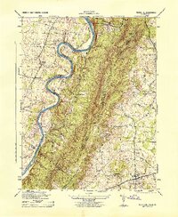
The Shenandoah River snakes through the western portion of this 1944 survey, defining the border between Jefferson and Clarke counties as it winds past Kabletown and Meyerstown. The terrain is dominated by the Blue Ridge mountains, where the Appalachian Trail follows the ridge line through Wilson Gap and past the distinctive Raven Rocks. This era reveals a rural landscape anchored by local institutions such as the Mountain Mission, Fairmont Church, and the Blue Ridge School. To the east, the village of Round Hill serves as a hub near the South Fork Catoctin Creek, surrounded by small settlements like Eubanks. The map provides a detailed view of the mid-century road network and drainage patterns, including Bullskin Run and Long Marsh Run, reflecting the agricultural and natural character of the Virginia-West Virginia borderlands during the war years.
Find a feature on this map
24 named features on this map. Tap any name to fly to it.
Don’t see what you’re looking for? This feature index may not catch every label — zoom into the map to look around manually.
Map Details
Editions of this 1944 Round Hill Map
This is the sole edition of this map. No revisions or reprints were ever made.
Other maps of this area

1884 · Harpers Ferry
USGS Topo · 1:125,000

1891 · Harpers Ferry
USGS Topo · 1:125,000

1893 · Harpers Ferry
USGS Topo · 1:125,000

1908 · Middletown
USGS Topo · 1:48,000

1910 · Antietam
USGS Topo · 1:62,500

1914 · Martinsburg
USGS Topo · 1:48,000

1916 · Martinsburg
USGS Topo · 1:62,500

1916 · Berryville
USGS Topo · 1:62,500

1939 · Berryville
USGS Topo · 1:48,000
1943 · Bluemont
USGS Topo · 1:24,000