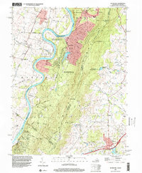
1997 Map of Round Hill
USGS Topo · Published 2001About this map
The Shenandoah River carves a deep winding path through the borderlands of West Virginia and Virginia, defining the transition from the river valley to the high ridges. Along the eastern edge, the Blue Ridge mountains dominate the landscape, traversed by the Appalachian National Scenic Trail as it passes through Wilson Gap and past the distinctive Raven Rocks. This late 20th-century survey shows the community of Round Hill at the southeastern foot of the ridge, while the western side of the river features established rural settlements like Kabletown and Meyerstown. The area's cultural history is marked by several local landmarks, including the Kabletown Sch, St Andrews Ch, and the Ketocktin Cem. The extensive Shannondale Springs State Wildlife Management Area preserves the riverbanks, where the water flows past Parker Island and under the shadows of the high mountain gaps.
Find a feature on this map
48 named features on this map. Tap any name to fly to it.
Don’t see what you’re looking for? This feature index may not catch every label — zoom into the map to look around manually.
Map Details
Editions of this 1997 Round Hill Map
This is the sole edition of this map. No revisions or reprints were ever made.
Other maps of this area

1884 · Harpers Ferry
USGS Topo · 1:125,000

1891 · Harpers Ferry
USGS Topo · 1:125,000

1893 · Harpers Ferry
USGS Topo · 1:125,000

1908 · Middletown
USGS Topo · 1:48,000

1910 · Antietam
USGS Topo · 1:62,500

1914 · Martinsburg
USGS Topo · 1:48,000

1916 · Martinsburg
USGS Topo · 1:62,500

1916 · Berryville
USGS Topo · 1:62,500

1939 · Berryville
USGS Topo · 1:48,000

1943 · Bluemont
USGS Topo · 1:24,000