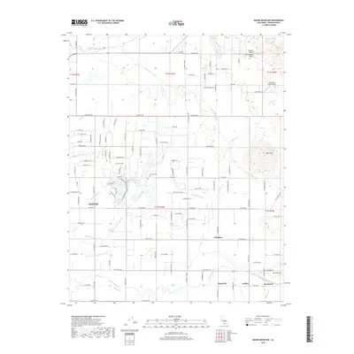
2018 Map of Round Mountain
USGS Topo · Published 2018About this map
The agricultural landscape of the Central Valley is defined by a dense network of irrigation infrastructure east of Clovis. This area in Fresno County exhibits a complex system of water management, with the massive Friant-Kern Canal cutting through the terrain alongside historical works like the Fairview Ditch, Gray Colony Ditch, and Gould Canal. These waterways serve the orchards and vineyards surrounding smaller settlements such as Edmiston, Zediker, and Big Bunch. The topography transitions from the flat valley floor toward the foothills, marked by distinctive landforms like Round Mountain and Kirkman Hill. Family-owned operations and local landmarks, including the Kindsvater Ranch Airport and the Redbank Cemetery, provide anchor points for genealogists and local historians tracing the development of this fertile region. The presence of the Fresno Canal and its various branches underscores the long-standing reliance on engineered water to sustain the San Joaquin Valley's economy.
Find a feature on this map
70 named features on this map. Tap any name to fly to it.
Don’t see what you’re looking for? This feature index may not catch every label — zoom into the map to look around manually.
Map Details
Editions of this 2018 Round Mountain Map
This is the sole edition of this map. No revisions or reprints were ever made.
Other maps of this area

1920 · Orangedale School
USGS Topo · 1:24,000

1922 · Round Mountain
USGS Topo · 1:31,680

1922 · Trimmer
USGS Topo · 1:96,000

1922 · Friant
USGS Topo · 1:31,680

1923 · Malaga
USGS Topo · 1:31,680

1923 · Academy
USGS Topo · 1:31,680

1923 · Orangedale School
USGS Topo · 1:31,680

1923 · Clovis
USGS Topo · 1:31,680

1923 · Wahtoke
USGS Topo · 1:31,680

1923 · Sanger
USGS Topo · 1:31,680