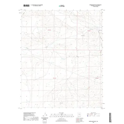
2020 Map of Round Mountain SE
USGS Topo · Published 2020About this map
Arroyo del Macho and Gallo Arroyo define the drainage patterns of this Chaves County landscape, where the seasonal movement of water has carved a network of draws and named catchments. The area is characterized by its vital water infrastructure, including Twin Tanks, Columbus Tank, and North Tank, which support the high-desert environment across several sections of the Public Land Survey System. These features, along with Roach Draw and Cowboy Draw, suggest a region long-adapted for cattle ranching or land management. Transportation is limited to a handful of thoroughfares such as Stargrass Rd and Silverweed Rd, which cut through the vast tracts of T5S and T6S. This survey provides a precise accounting of the hydrological and man-made improvements in this remote New Mexico territory.
Find a feature on this map
15 named features on this map. Tap any name to fly to it.
Don’t see what you’re looking for? This feature index may not catch every label — zoom into the map to look around manually.
Map Details
Editions of this 2020 Round Mountain SE Map
This is the sole edition of this map. No revisions or reprints were ever made.
Other maps of this area

1955 · Roswell
USGS Topo · 1:250,000

1958 · Roswell
USGS Topo · 1:250,000

1962 · Roswell
USGS Topo · 1:250,000

1962 · Rock House Canyon
USGS Topo · 1:24,000

1967 · Round Mountain SE
USGS Topo · 1:24,000

1967 · North Lake
USGS Topo · 1:24,000

1967 · White Flat
USGS Topo · 1:24,000

1967 · Round Mountain
USGS Topo · 1:24,000

1967 · Chivata Canyon
USGS Topo · 1:24,000
1967 · Mesa SW
USGS Topo · 1:24,000