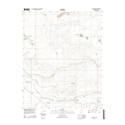
2014 Map of Round Rock
USGS Topo · Published 2014About this map
Round Rock stands at the southern end of this high-desert landscape, where the confluence of Lukachukai Creek and several seasonal washes defines the local geography. The area is characterized by dramatic geological formations, from the towering Los Gigantes Buttes in the northeast to the sprawling Red Clay Mesa that overlooks the valley floor. Transportation through this part of the Shiprock Agency relies on routes like Us-191 and various Bureau of Indian Affairs roads, including Bia-12 and Bia-172, which connect the scattered water sources and topographical landmarks. Water management is critical in this arid environment, evidenced by the presence of White Water Reservoir and numerous named springs such as Pigeon Spring and Mexican Spring. The map reveals a land shaped by erosion, featuring distinct points and gaps like Blue Gap Point and The Rock Gap that serve as natural waypoints in the Hasbidito Valley.
Find a feature on this map
36 named features on this map. Tap any name to fly to it.
Don’t see what you’re looking for? This feature index may not catch every label — zoom into the map to look around manually.
Map Details
Editions of this 2014 Round Rock Map
This is the sole edition of this map. No revisions or reprints were ever made.
Other maps of this area

1892 · Canyon De Chelly
USGS Topo · 1:250,000

1953 · Los Gigantes NE
USGS Topo · 1:24,000

1953 · Los Gigantes NW
USGS Topo · 1:24,000

1953 · Los Gigantes SE
USGS Topo · 1:24,000

1953 · Los Gigantes SW
USGS Topo · 1:24,000

1953 · Los Gigantes Buttes
USGS Topo · 1:62,500

1954 · Shiprock
USGS Topo · 1:250,000

1955 · Sonsala Butte 2 NW
USGS Topo · 1:24,000
1955 · Sonsala Butte 2 NE
USGS Topo · 1:24,000
1955 · Yellowstone Canyon
USGS Topo · 1:62,500