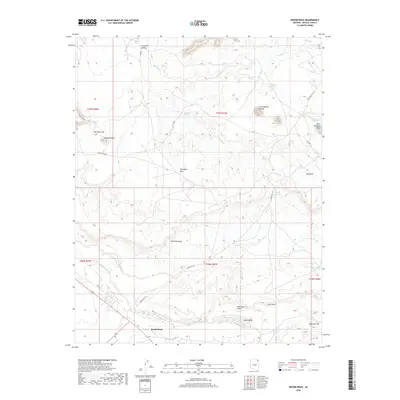
2018 Map of Round Rock
USGS Topo · Published 2018About this map
Round Rock and Rock Pointing West anchor this survey of the high desert plateau within the Navajo Nation. The terrain is defined by dramatic geological formations, most notably the prominent Los Gigantes Buttes and the sprawling Red Clay Mesa. Water sources are critical points of interest in this arid environment, marked by numerous named seeps such as Tohatchi Spring, Pigeon Spring, and the Tsa-Yah Das Iahi Spring. In the northern portion, the Hasbidito Valley provides a natural corridor for Hasbidito Cr, while the southern reaches are drained by Lukachukai Creek. For those studying the traditional movement across this landscape, the map reveals a network of local routes like Indian Rte 172 and Indian Rte 8009, connecting isolated landmarks like The Rock Gap and Gun Point.
Find a feature on this map
36 named features on this map. Tap any name to fly to it.
Don’t see what you’re looking for? This feature index may not catch every label — zoom into the map to look around manually.
Map Details
Editions of this 2018 Round Rock Map
This is the sole edition of this map. No revisions or reprints were ever made.
Other maps of this area

1892 · Canyon De Chelly
USGS Topo · 1:250,000

1953 · Los Gigantes NE
USGS Topo · 1:24,000

1953 · Los Gigantes NW
USGS Topo · 1:24,000

1953 · Los Gigantes SE
USGS Topo · 1:24,000

1953 · Los Gigantes SW
USGS Topo · 1:24,000

1953 · Los Gigantes Buttes
USGS Topo · 1:62,500

1954 · Shiprock
USGS Topo · 1:250,000

1955 · Sonsala Butte 2 NW
USGS Topo · 1:24,000
1955 · Sonsala Butte 2 NE
USGS Topo · 1:24,000
1955 · Yellowstone Canyon
USGS Topo · 1:62,500