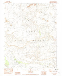
1982 Map of Round Rock
USGS Topo · Published 1983About this map
Round Rock and the nearby Chapter House serve as the focal point of this northern Navajo Indian Reservation landscape, where high-desert mesas meet a complex network of seasonal washes and spring-fed points. The terrain is defined by dramatic geological features such as the Los Gigantes Buttes and Standing Rock, while essential water sources like Pigeon Spring, Mexican Spring, and the White Water Reservoir suggest the vital infrastructure required for life in this arid region. The map captures a moment in the early 1980s when traditional land use is evidenced by an Arena, an Earth Tank, and a Ditch system near the main settlement. From the heights of Blue Cap Point to the broad expanse of Sifting Coyote Mesa, the survey reveals a geography where every named spring and wash, including Hasbidito Creek and Lukachukai Wash, represents a critical landmark for navigation and survival.
Find a feature on this map
30 named features on this map. Tap any name to fly to it.
Don’t see what you’re looking for? This feature index may not catch every label — zoom into the map to look around manually.
Map Details
Editions of this 1982 Round Rock Map
This is the sole edition of this map. No revisions or reprints were ever made.
Other maps of this area

1892 · Canyon De Chelly
USGS Topo · 1:250,000

1953 · Los Gigantes NE
USGS Topo · 1:24,000

1953 · Los Gigantes NW
USGS Topo · 1:24,000

1953 · Los Gigantes SE
USGS Topo · 1:24,000

1953 · Los Gigantes SW
USGS Topo · 1:24,000

1953 · Los Gigantes Buttes
USGS Topo · 1:62,500

1954 · Shiprock
USGS Topo · 1:250,000

1955 · Sonsala Butte 2 NW
USGS Topo · 1:24,000
1955 · Sonsala Butte 2 NE
USGS Topo · 1:24,000
1955 · Yellowstone Canyon
USGS Topo · 1:62,500