
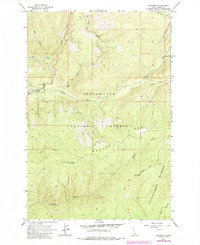
1964 Map of Roundtop
USGS Topo · Published 1967About this map
Beaver Ridge dominates this mid-1960s survey of the Idaho backcountry, where the Clearwater National Forest meets the northern reaches of the Selway-Bitterroot Wilderness. The landscape is defined by an intricate network of drainage systems, including the Crooked Fork and its tributaries like Haskell Creek and Brushy Fork. Human presence is represented primarily by infrastructure for forest management and backcountry access, such as the Lookout Tower positioned atop the summit of Roundtop. A system of historic transit routes is visible throughout the area, notably the Pack Trail segments that navigate the steep terrain between Elk Meadows and the various forks of the Beaver Creek drainage. This map captures the region in its role as a protected wilderness area before significant modern alterations, preserving the routes and names used by foresters and early wilderness travelers.
Find a feature on this map
21 named features on this map. Tap any name to fly to it.
Don’t see what you’re looking for? This feature index may not catch every label — zoom into the map to look around manually.
Map Details
Editions of this 1964 Roundtop Map
2 editions found
Other maps of this area

1901 · Hamilton
USGS Topo · 1:125,000

1911 · Lolo
USGS Topo · 1:250,000

1912 · Missoula
USGS Topo · 1:125,000

1913 · Lolo
USGS Topo · 1:250,000

1956 · Hamilton
USGS Topo · 1:250,000

1959 · Hamilton
USGS Topo · 1:250,000

1960 · Hamilton
USGS Topo · 1:250,000

1964 · Hamilton
USGS Topo · 1:250,000

1964 · Lolo Hot Springs
USGS Topo · 1:24,000

1964 · West Fork Butte
USGS Topo · 1:24,000